Authors: Ronan Ysebaert, Marianne Guérois, Louis Laurian, RIATE
Accessibility Is a crucial element of our everyday’s life and a backstone for economic development and service provision. Yet, accessibility is still a major concern for rural and remote areas. This blog post provides a brief summary on the EU policy attention to enable accessibility for rural areas, existing initiatives and ongoing challenges. Hence, it discusses the authors’ work to obtain more granular data on rural accessibility and mobility data.
Accessibility – a major policy issue in EU
Accessibility is a major issue in the EU narratives since the Maastricht Treaty of 1992, when the concept of Trans-European transport Networks (TEN) was introduced for the first time (Spiekermann et al. 2015). The idea behind is the assumption that transport infrastructures and accessibility are necessary conditions for economic growth in the Union, having a direct impact on the attractiveness of regions for business and people. This led to important research and indicators creation at regional scale on potential accessibility to economy or labour market .
Since the economic crisis of 2010’s, global discourse based on economic growth has slightly moved: the Territorial Agenda of the European Union stated that a fair and affordable accessibility to services of general interest, information, knowledge and mobility are essential for territorial cohesion. Providing services and minimising infrastructure barriers can improve competitiveness, and the sustainable and harmonious territorial development of the European Union (European Union 2020a).
Still today, in the Territorial Agenda 2030 of the EU (European Union 2020b) remains the need to enable more equal opportunities, including accessibility and affordability to public services for people and enterprises, whatever they are located (art.6, 26, 27, 30, 47, 50, 62). The Territorial Agenda 2030 underlines that this especially concerns remote areas that lack access to public services and economic and social opportunities (art.28). Amid climate adaptation and ecological urgency, the imbalance between resource and population distribution gains importance. This is especially evident in car-dependent rural areas, where escalating fuel prices worsen access challenges to essential resources (Gallez 2023).
Existing initiatives & challenges
Numerous projects and researches have been carried out at EU scale to support these policy perspectives (Mathis et al. 2004; Spiekermann et al. 2015; Kluge and Spiekermann 2017, Kompil et al. 2019; Noguera et al. 2017; Kompil et al. 2022). These initiatives offer concepts, methods, indicators, tools, and recommendations for monitoring accessibility measures in Europe. While assisting policymakers in understanding transport and service investment needs, they also highlight at least three limitations, prompting further investigation.
- Rural-oriented approach: Most indicators focus on the accessibility of territories to urban functions (transport hubs, employment areas, population centers or services concentrations). Adjusting the focus to smaller territorial centralities, crucial in rural areas, is essential. Existing ones in rural regions must also be taken into account.
- Local scale: Most indicators and analysis are aggregated at NUTS levels (NUTS2, NUTS3). While valuable for an overview of the European area, a finer geographical grain is needed to address intra-regional disparities and identify local challenges, particularly in rural areas.
- Reproducibility and open-source solutions: Existing European indicators rely on proprietary and costly data for transport networks, posing challenges to reproducibility and maintenance of core accessibility indicators.
Building a Reproducible Framework with Open-Source Solutions
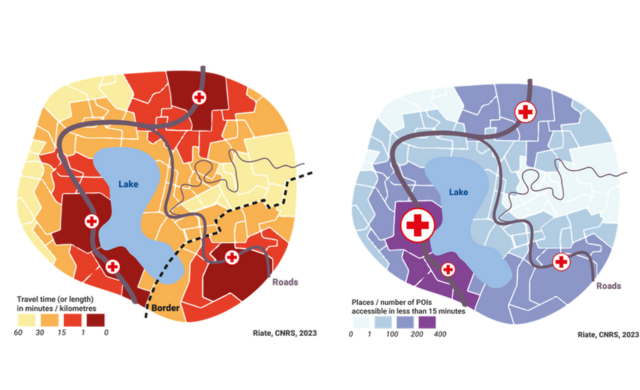
RIATE (CNRS – Université Paris Cité) aims at producing a reproducible, transparent and updatable framework to compute accessibility indicators based on open source and free routing engines, such as OSRM or Valhalla. These routing engines are based on OpenStreetMap (OSM) network and make possible the creation of travel time indicators for a set of origins and destinations.
A first challenge to overcome consists in identifying a relevant destination layer (completeness, quality, relevant for rural areas) to compute accessibility indicators. A quality assessment has been realised on OSM data to identify potential Points of Interest that fits with GRANULAR Rural Compass components (public services, recreational activities, cultural amenities, etc.). Results appear promising but completeness of the OSM database is unfortunately too poor at the moment to make results consistent in EU perspective, especially for rural areas.
Another experiment is currently undergoing on EU towns and cities, recently made available by the Joint Research Centre and based on a common methodology for all Europe. This layer can be considered as a proxy to identify little and medium commercial centralities in Europe. In 2024, travel time and associated accessibility indicators based on this destination layer will be computed for entire Europe at local scale. Important attention will be paid to data quality, reproducibility and methodology documentation. It is namely expected to use outputs derived from this framework to feed the GRANULAR territorial typology for rural diversity.
If you are interested to know more, you can check it out at OpenStreetMap data and associated routing engine to produce novel data on rural areas in Europe!
